Obtain the data you need to make the most informed decisions by accessing our extensive portfolio of information, analytics, and expertise. Sign in to the product or service center of your choice.
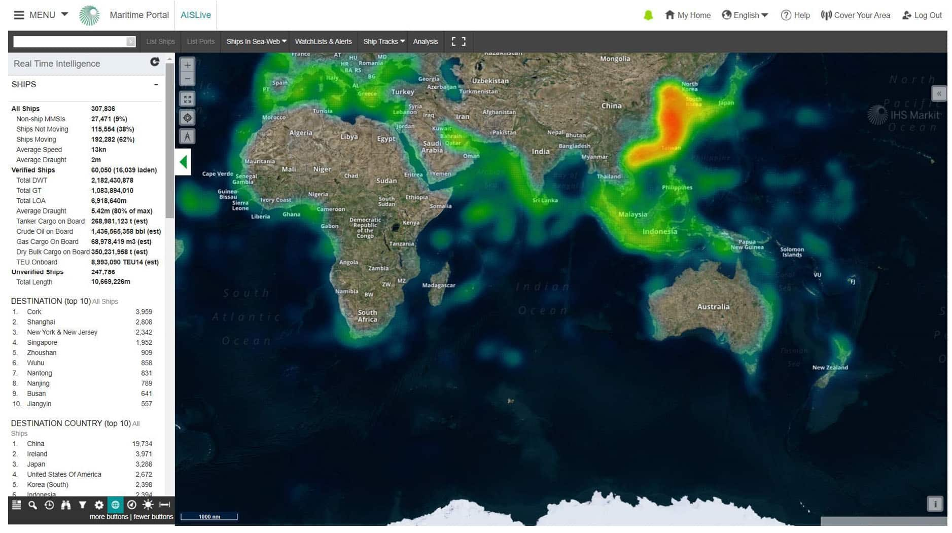
Real time ship monitoring and real-time intelligence for vessel activity.
What if you could pinpoint a ship’s location down to the minute with one tool?
The industry's first online software for tracking real-time marine traffic, AISLive delivers updated movements for 130,000+ ships and vessels every 60 seconds, including activity at 16,000+ ports and terminals worldwide. Available through three different subscription levels, AISLive Premium includes access to terrestrial and satellite ship movements and to the Sea-web Ports module for greater visibility into your fleet’s deep sea and offshore movements. All AISLive subscriptions offer a user-friendly mapping tool and 197 search filters. Find out how you can connect your port or area to the AISLive network.
You can learn more about AISLive in the following languages: Chinese and Korean.
Marine equipment companies, port authorities and service providers, ship owners, managers, agents, charterers and brokers as well as government and civil authorities use AISLive to:
Boost operational efficiencies: Follow your fleet’s global movements – routes, speeds, arrival times – including deep sea activity
Enhance domain awareness: Track all ships sailing in your waters
Uncover ship movement and commodity trade trends: Reveal competitor positions, create trading positions and identify business opportunities
Mitigate risk: Identify, watch and set alerts for ships that could be a security risk in your waters
Sky-to-Sea Data: Satellite and terrestrial online coverage of real-time ship movements 24/7 worldwide (satellite data available with AISLive Premium only)
Search Filters: 197 filters including all ships (destination port/country, ETA, draught, speed and hazardous cargo, current position, last seen) and verified ships (DWT, GT, flag, operator, technical manager, last port of call and last country of call)
Zoom-in/Zoom-out: Zoom in to a narrowly defined perimeter and create an automatic list of ships in that area and link to specific ship detail; zoom out for a global view to see the density of ships around the world, then create a watchlist of only ships you are interested in by ship type, destination, arrival ETA and other variables
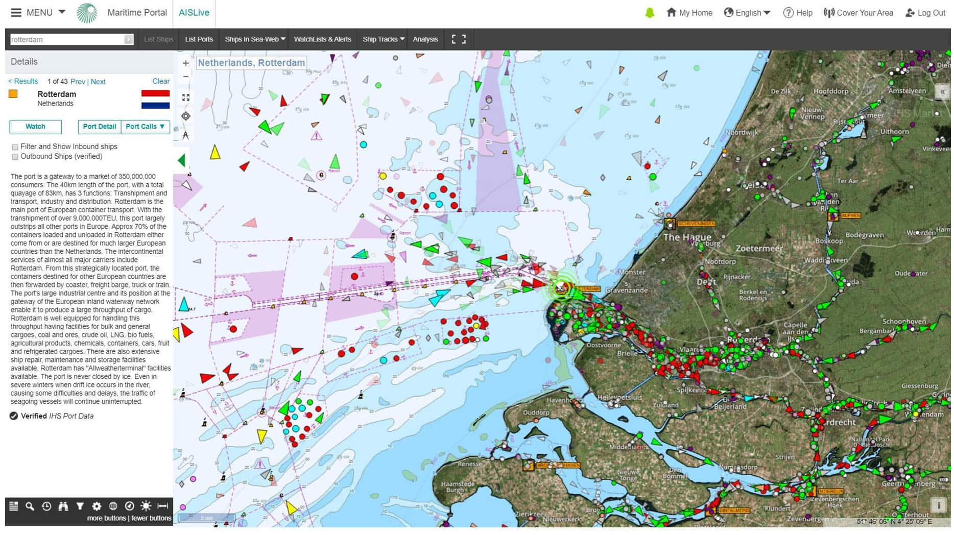
Multilayered Mapping Tool: 4 different map views so you can identify high/low areas of traffic density and view ports, tanker and dry cargo berths
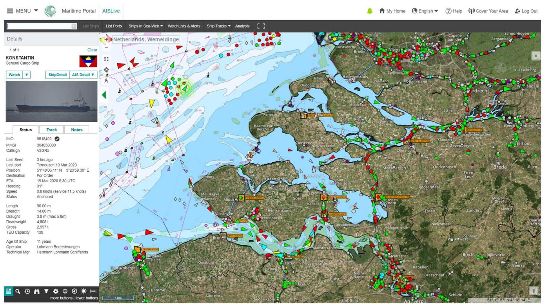
Verified Ship Data: Ship name, technical manager, commercial operator, type, call sign, dimensions and photos – Maritime & Trade holds the largest maritime ships database in the world and is the sole appointed authority for assigning and validating the IMO ship and company numbers
Distance Tables Module: Calculate a ship’s arrival with greater accuracy
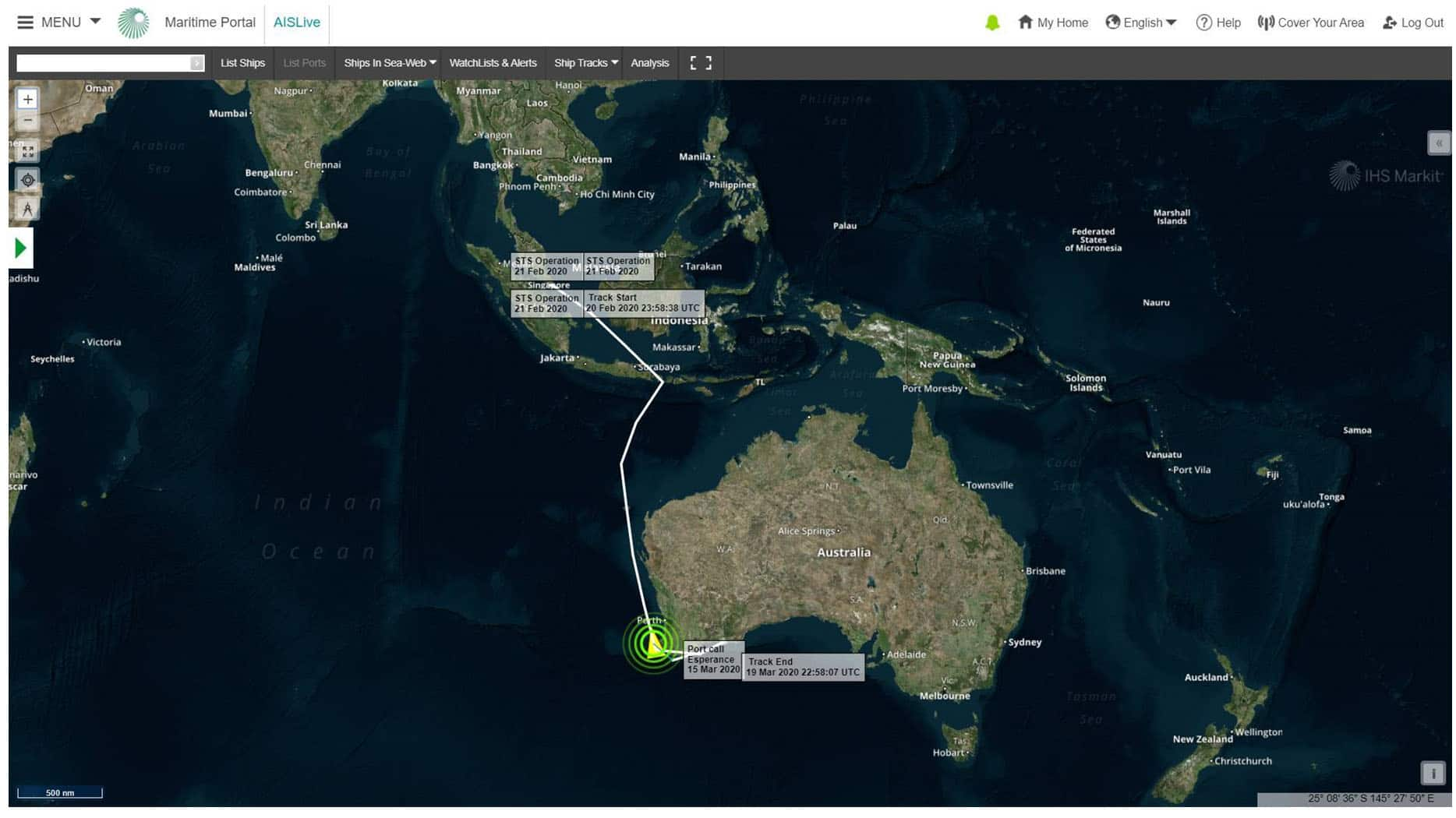
Ship Track on Map: Up to 90 days for MMSI ship track; back to 2005 for IMO ship track (AISlive premium only); hide other ships on the map to see only the track for your ship; add animation to see dates and speed along the shiptrack
Seamless Connectivity to Sea-web the ultimate marine reference tool (AISLive Plus and AISLive Premium only)
AISLive Station Hosts (add-on module): Receive an email alert 24/7 when your station has lost connectivity to the AISLive network. In addition, hosts get access to our station-monitoring software and customer care support team to troubleshoot any connectivity issues
Network Coverage: Europe, North America, the Caribbean, Mediterranean and Far East, including live global port callings, with more antenna stations being added all the time
AISLive ShipWatch Services: Automated service that triggers an email alert when a selected ship enters a specified zone as well as immediate notifications when a ship has changed its destination or estimated time of arrival
Watch Lists: Create a list of ships to monitor and set up a range of email alerts for those ships; filter map to display watch list ships only
Alerts: 4 types of email alerts so you know when a ship enters a port or area of interest and you learn the latest arrival, departure and itinerary changes
Itinerary Change Alerts: Find out when a crew changes the destination or time of arrival on its transponder
Zone Alerts: Learn when a ship you have specified enters a certain area, up to 160 nautical miles radius, with the ability to set more than one zone alert on a ship
Port Arrival Alerts: Get email notification when a ship arrives at a port
Daily Noon Report Alerts: Discover the latest positions and information for your watch-list ships
Compare AISLive Subscription Services
AISLive Standard = terrestrial ship movements
AISLive Plus = terrestrial ship movements + the Sea-web Ports module
AIS stands for Automatic Identification of System and is officially classed as being primarily an aid to navigation rather than a vessel tracking system. It was designed with the aim of improving vessel safety by increasing the situational awareness of nearby traffic, and with a secondary function of allowing the monitoring of traffic by vessel traffic systems, port authorities and other government agencies. It is this secondary monitoring function which has been further developed and exploited to provide the global vessel tracking systems in use today.
AIS works by allowing individual vessels to automatically broadcast a regularly updated series of structured messages containing navigation and identity information to other vessels in their immediate vicinity. Messages are broadcast on one of two VHF radio frequencies (161.975Mhz & 162.025Mhz) and the contents conform to one of 27 pre-defined message formats. The system is designed to be self-organising with the individual transmitters synchronizing themselves with each other, to avoid overlapping transmissions. Each message then being sent using one or two of the 2250 time slots established every minute on each channel.
The best 24/7 AIS coverage comes from terrestrial AIS receivers and is based on their radio line of sight. This, in turn, is dependent on both the height of the transmitting and receiving AIS aerials but typically extends out to around 30 nautical miles for larger vessels. Beyond this range, a weather-based phenomenon known as tropospheric ducting often provides enhanced reception thereby extending coverage by 10’s or even sometimes 100’s of miles. This effect is however highly directional, variable in strength and seasonal being more prevalent in warmer weather, it, therefore, cannot be relied on alone. For areas outside the coverage of terrestrial land-based antennas most AIS monitoring is provided by satellite-based AIS receivers which cover the whole globe from pole to pole, this provides in general excellent coverage for vessels in mid ocean, and the southern hemisphere in general.
The legal requirements and policies for the use of AIS class A were formulated by the International Maritime Organisation, and form part of SOLAS Chapter V - Safety of Navigation - Regulation 19 - Carriage requirements for shipborne navigational systems and equipment.
The technical requirements of the AIS system are specified by The International Telecommunications Union (ITU) and are laid out chiefly in their publication.
Recommendation ITU-R M.1371-5(02/2014) - Technical characteristics for an automatic identification system using time division multiple access in the VHF maritime mobile frequency band.
Within territorial waters enforcement of AIS standards, the accuracy of transmissions, and any special local requirements for AIS fitment and use is the responsibility of the individual nation states.